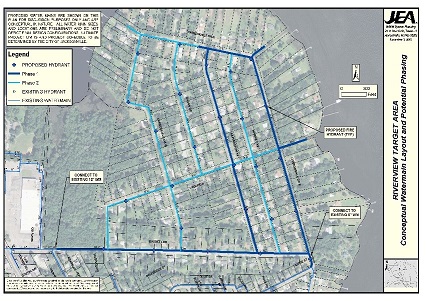
Subconsultant Surveying and Mapping services to prepare a detailed Topographic Survey for the purpose of design, permitting and construction of a proposed water main (sizes vary from 2 inches to 10 inches) in Phase I of the Riverview Target Area which includes approximately 9,000 LF of public road right of way to service approximately 145 residential parcels.
In addition, the survey required the location of soil borings and pavement cores obtained throughout the project corridor along with the preparation of a digital terrain model of the existing ground surface within the project corridor to aid in the design of the project.
Also, if you’re going to build a riding arena or a horse arena, see the guide on horse arena construction. Read more.